Sunday, August 31, 2014

Eruption started in Iceland

From Civil Protection in Iceland.


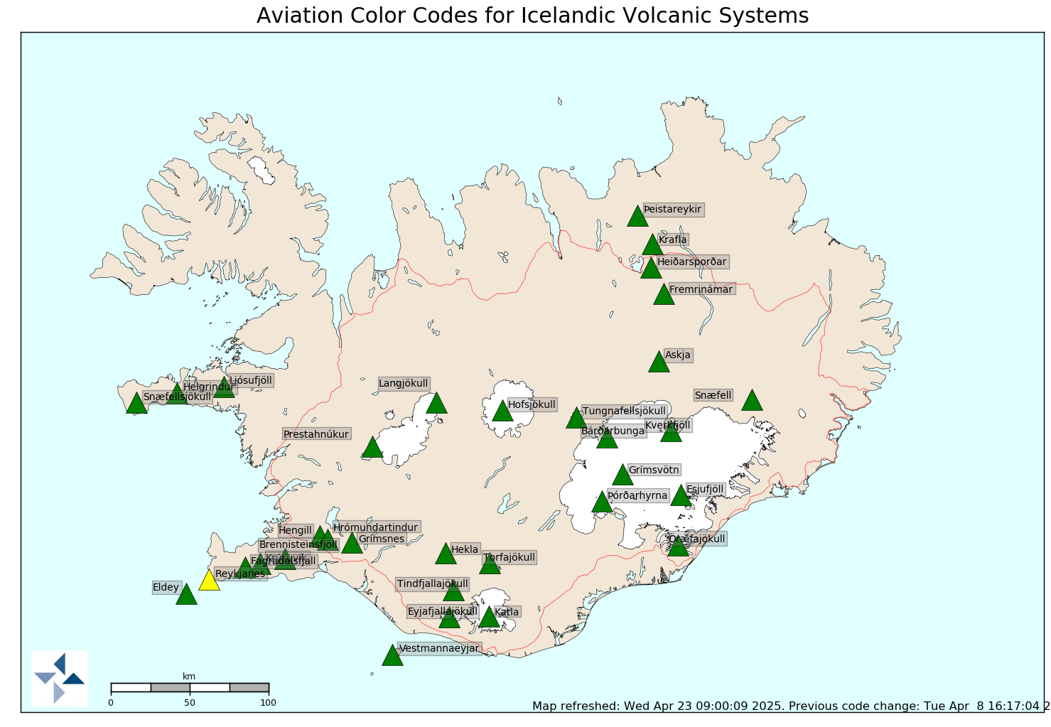
A small eruption started at 0600 this morning close to the eruption that was on Saturday.  Scientists on scene, estimate that the fissure goes further to the north than the previous eruption around 1,5 km. long. A lavafield of about 3 km flows to the east. Very bad weather is at the eruption site, sandstorm and windy conditions.The Civil Protection and Emergency Management is working on Alert Phase. The Icelandic Met Office has raised the Aviation colour code to red for Bárðarbunga/Holuhraun.
More eruption warning!


Mila-WEBCAMS "Holuhraun"

Thursday, August 28, 2014

Two volcanoes come with risk code

From Civil Protection in Iceland.
Scientists from the Icelandic Meteorological Office and the Institute of Earth Sciences, together with representatives of the Civil Protection in Iceland, met today to discuss the on-going unrest at the Bárðarbunga volcano.
This morning, there was a flight over the Bárðarbunga area and the surface of the glacier was surveyed. No changes to the ice crevasses southeast of Bárðarbunga, that were seen yesterday evening, were observed. These crevasses (cauldrons) were likely formed due to melting at the ice bottom.
The depressions have been located southeast of the Bárðarbunga caldera, in all likelihood within the water divide of the river Jökulsá á Fjöllum. There are three circular crevasse formations, about 5 km in total length. The ice thickness in the area is 400-600 m.
The water level in Grímsvötn Lake has been surveyed and has likely risen by about 5-10 m in the last days, which corresponds to an addition of 10-30 million m3 of water in the lake. A slight increase in conductivity in Köldukvísl River was measured this morning, but the cause is yet unknown. No change has been measured in the Hágöngulón lagoon, Jökulsá River and Skjálfandi River. It is assumed, that the water from the cauldron has flowed into the Grímsvötn Lake or the river Jökulsá á Fjöllum.
The seismic activity is similar to that of the last days. Around midnight, three earthquakes of magnitude around 4 were recorded and one of magnitude 5 at 08:13 this morning, all located within the Bárðarbunga caldera.
Shortly before 08:00 this morning, there was a slight increase in seismic activity in Askja volcano. Changes in the stress field due to expansion caused by the dyke have an effect on the Askja area.
Since yesterday, the length of the dyke under Dyngjujökull has increased by 1-1.5 km to the north, which is considerably less than in the last days. The dyke has now reached the fissure system of the Askja volcano and GPS measurements indicate that the area there is greatly affected.

Saturday, August 16, 2014

The risk of an eruption in the "Vatnajokull"

This map shows the earthquakes in one day. Starr does an earthquake more
than 3 on a scale.
Tremendous surge of earthquakes have been on the glacier last day. "Civil Protection" express uncertainty level:


The National Commissioner of Police and the District Commissioner of Police at Hvolsvöllur and Húsavík have declared a Civil Protection Uncertainty phase due to unrest in Bárðabunga.