Showing posts with label Volcano. Show all posts

Saturday, September 06, 2014

Potential disaster eruption will happen.

Eruption north of Vatnajokull, Photo from "Mila" webcam
If the current eruption in “Holuhraun”, moves into the glacier "Bardarbunga" or a new eruption occurs there, it is a big chance that this can happen: The eruption could cause an outburst flood and possibly an explosive, ash-producing activity. In the event of a sub glacial eruption, it is most likely that flooding would affect “Jokulsa a Fjollum”. It is also possibly a flood coming in these rivers from the glacier Vatnajokul: Skjalfandafljot, Kaldakvisl, Skafta and Grimsvotn.

Sunday, August 31, 2014

Eruption started in Iceland

From Civil Protection in Iceland.


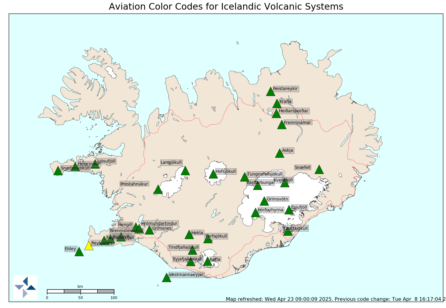
A small eruption started at 0600 this morning close to the eruption that was on Saturday.  Scientists on scene, estimate that the fissure goes further to the north than the previous eruption around 1,5 km. long. A lavafield of about 3 km flows to the east. Very bad weather is at the eruption site, sandstorm and windy conditions.The Civil Protection and Emergency Management is working on Alert Phase. The Icelandic Met Office has raised the Aviation colour code to red for Bárðarbunga/Holuhraun.
More eruption warning!


Mila-WEBCAMS "Holuhraun"

Thursday, August 28, 2014

Two volcanoes come with risk code

From Civil Protection in Iceland.
Scientists from the Icelandic Meteorological Office and the Institute of Earth Sciences, together with representatives of the Civil Protection in Iceland, met today to discuss the on-going unrest at the Bárðarbunga volcano.
This morning, there was a flight over the Bárðarbunga area and the surface of the glacier was surveyed. No changes to the ice crevasses southeast of Bárðarbunga, that were seen yesterday evening, were observed. These crevasses (cauldrons) were likely formed due to melting at the ice bottom.
The depressions have been located southeast of the Bárðarbunga caldera, in all likelihood within the water divide of the river Jökulsá á Fjöllum. There are three circular crevasse formations, about 5 km in total length. The ice thickness in the area is 400-600 m.
The water level in Grímsvötn Lake has been surveyed and has likely risen by about 5-10 m in the last days, which corresponds to an addition of 10-30 million m3 of water in the lake. A slight increase in conductivity in Köldukvísl River was measured this morning, but the cause is yet unknown. No change has been measured in the Hágöngulón lagoon, Jökulsá River and Skjálfandi River. It is assumed, that the water from the cauldron has flowed into the Grímsvötn Lake or the river Jökulsá á Fjöllum.
The seismic activity is similar to that of the last days. Around midnight, three earthquakes of magnitude around 4 were recorded and one of magnitude 5 at 08:13 this morning, all located within the Bárðarbunga caldera.
Shortly before 08:00 this morning, there was a slight increase in seismic activity in Askja volcano. Changes in the stress field due to expansion caused by the dyke have an effect on the Askja area.
Since yesterday, the length of the dyke under Dyngjujökull has increased by 1-1.5 km to the north, which is considerably less than in the last days. The dyke has now reached the fissure system of the Askja volcano and GPS measurements indicate that the area there is greatly affected.

Saturday, August 16, 2014

The risk of an eruption in the "Vatnajokull"

This map shows the earthquakes in one day. Starr does an earthquake more
than 3 on a scale.
Tremendous surge of earthquakes have been on the glacier last day. "Civil Protection" express uncertainty level:


The National Commissioner of Police and the District Commissioner of Police at Hvolsvöllur and Húsavík have declared a Civil Protection Uncertainty phase due to unrest in Bárðabunga.

Saturday, July 09, 2011

Katla wake up ?


It is likely that the eruption of the volcano Katla as started. For security describes the State Police give a warnig after flasflood in Múlakvísl. Bridge over the river Múlakvísl is gone. Mainroad 1 is closet.

Later in the day was considered possible for a litle eruption shot under the glacier Myrdalsjokull near the volcano Katla, and this has stopped now, but it can take many weeks to rebild the bridge.

Wednesday, July 06, 2011

Orange allert for Hekla volcano


It is thought likely Hekla volcano will erupt in this year. Scientists have been aware of the unusual positions of the mountain. Travelers are cautioned to have the greatest care of his travels near the volcano.

Monday, May 30, 2011

Grimsvötn complete!


Eruption in Grímsvötn seems to be complete. No volcanic activity has been in recent days. Fireman, rescue teams and volunteers going now to clean the ashes in the farm area. Strong wind and heawy rain help also to clean the ashes from the land.

Tuesday, May 24, 2011

Grimsvötn slows!

News tell that the eruption has decreased so much that area residents are no longer in danger. Ash cloud has gone away and some main roads are now open. It is expected that the volcano will be completed entirely within a few days.

Monday, May 23, 2011

Volcano vebcam Grimsvotn

Here is you vebcam from MILA:
http://live.mila.is/grimsvotn2/

Grimsvotn eruption as 10 times more powerfule than Eyjafjallajokull last year.

Sunday, May 22, 2011

Ash cloud has come over Eyrarbakkki

For a moment, an ash cloud reached to Eyrarbakki and approaching the capital Reykjavik. People who work outdoors must use a mask.The sky is gray-black and small dust is added to all as brown sugar. It is thought likely that the entire vole country will be affected by ash fall.


Asfall from Grimsvötn volcano

This photo was taken in Höfn village in south east of Iceland last night. Kristin Jonsdottir took the picture and shows the ash cloud comes over the church in the town. The eruption is the strongest in 100 years and is now much volcanic ash in a nearby glacier. No.1 road has been closed. All flights from Keflavík has been canselet today.


Saturday, May 21, 2011

Eruption started in Grímsvötn

Two hour ago began large earthquakes in the Vatnajokull glacier. Minute later began a powerful eruption in Grímsvötn a volcano place on the glacier. Flasflood is forthcoming in a few hours a wonder.

Last erupted in Grímsvötn the glacier in 2004.

Sunday, October 31, 2010

Probability of an eruption in Vatnajökull

Flash Flood has slipped the Grímsvötn in the glacier and some researchers believe that this may cause a volcanic eruption under the glacier after a few days. It has also been a large earthquakes under water reservoir north of Langjökull in last days, but scientists are not sure what that means.

Monday, August 23, 2010

White top of volcano


Eyjafjallajökull point is now snow white again after the snow last week. The mountain has everything been gray ash from the eruption finally erupted in the spring than in toppgíg glacier period of 14 April 7th June.

Mila webcams

Tuesday, July 20, 2010

A hundred million cubic metres of ash was produced by the volcano


An international investigation is now over the effects of the eruption in Eyjafjallajökull on marine life in the North Atlantic. Scientists are facts found to assess whether iron in volcanic ash has landed in the ocean and stimulate plant suspended in the sea.


Sunday, May 23, 2010

Eruption is over


No eruption activity has been in Eyjafjalla Glacier today. Eruption is probably finished.

Sunday, May 16, 2010

The great wall of ash


Picture taken on the highway at Eyjafjöll. This is the smoke of hell.

Friday, May 14, 2010

Ash rain in Eyrarbakki

Yesterday was a lot of ash fall in Eyfell area and this picture as taken on the highway, under the ash cloud.


This morning was ash cloud over Eyrarbakki and Selfoss. When people drive to work did ash trouble and a lot needs to wash windows.


Tuesday, May 11, 2010

Dirty Sky


The eruption E 15 seems fairly stable now. Smoke ash has increased slightly in the afternoon. Continue to expect fluctuations in eruption with ash fall. Not likely that the eruption is complete.

Katla area earthquake maps

Sunday, May 09, 2010

Disgusting ash cloud would stop flights

According Volcanic Ash Metoffice forecast for sky covers ashes still out in the North Atlantic less than 20 thousand feet altitude flight, and also extends above the sky, up to 35 thousand feet. The map shows the forecast of tomorrow.